Dot Map of the USA
The Weldon Cooper Center at the University of Virginia put together on e of the most impressive maps that I have seen in a while this past June. The Racial Dot Map is:
an American snapshot; it provides an accessible visualization of geographic distribution, population density, and racial diversity of the American people in every neighborhood in the entire country. The map displays 308,745,538 dots, one for each person residing in the United States at the location they were counted during the 2010 Census. Each dot is color-coded by the individual's race and ethnicity.
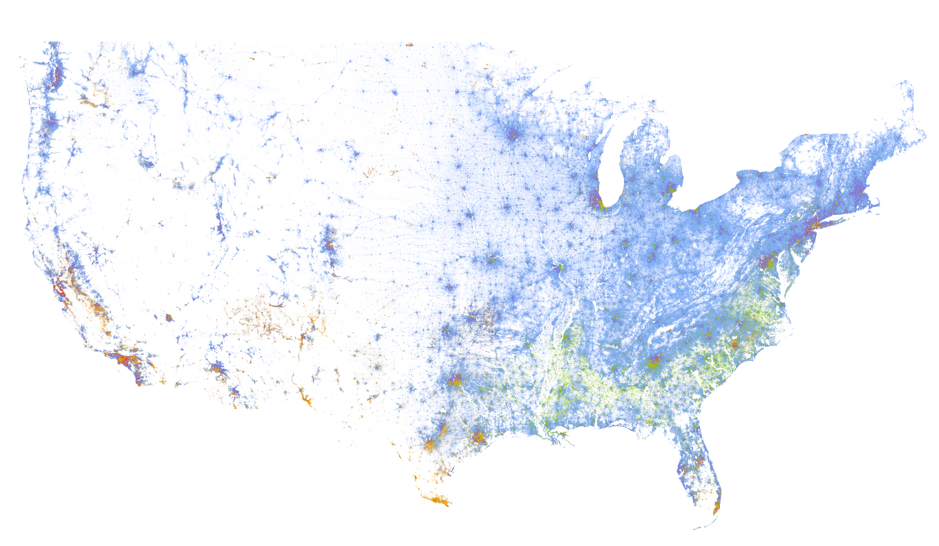
There a couple things that I think are very interesting about the map. The methods used are pretty cool where the creator, Dustin Cable, coded the map using Python and a whole set of skills that I do not possess. It highlights the insight that can be gained when skill sets are combined - for instance I am certain that an urban planner would have a deeper understanding at the extent of racial segregation in a city like Boston (please let me know if I am out to lunch here). This insight is accomplished using a very minimal design (you can toggle names off/on) that is both effective and beautiful. Remember, all of the distinguishable features on this map are a result of dots with each dot representing a person. Wow.

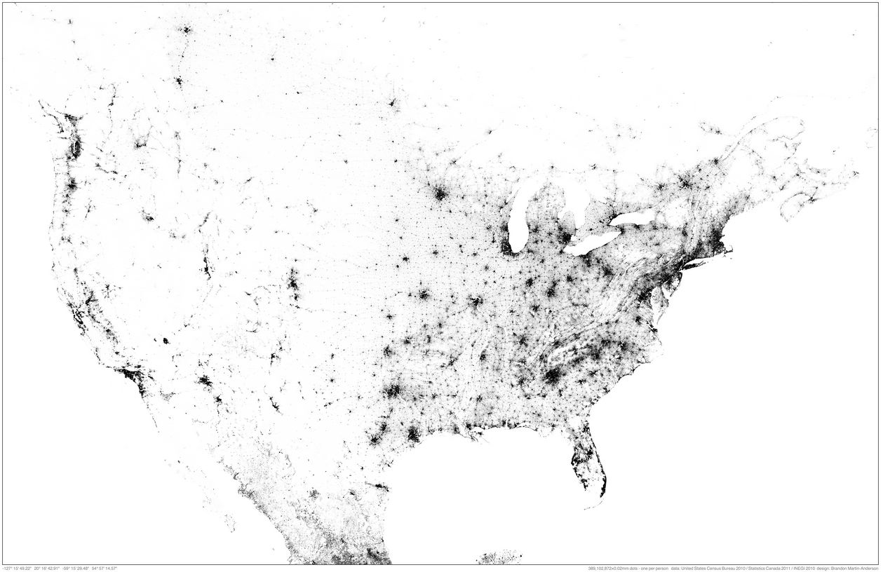
Finally, the map was inspired by a similar and equally remarkable Population Map of North America created by MIT Medial Lab researcher Brandon Martin-Anderson. The NA Population map contains 454 064 098 points - a very big data set!
The complete description of the Racial Dot Map can be found at the Cooper Center's site.
images of our city: ezio farone park
 Everyone knows Ezio Farone Park. Its the park at the top of the stairs adjacent to the Glenora Club, and is a node between the southside and downtown; the top of the bank with the river valley. I lived for years at 100 Avenue and 110 Street and love how cycling and pedestrian traffic flows north / south through Ezio. On winter days while walking down to the Kinsmen, I could feel the temperature drop as I descended down the stairs into the River Valley.
Ezio Farone park is named after Constable Ezio Farone, a member of the Edmonton Police Service who was killed in action on June 25th, 1990 (from Crime and Punishment website here). While the park is lauded by the running and stair walking community, it is more than just a stairway to fitness heaven. Ezio Farone is a hub of transportation and offer some of the best views of the River Valley, the University and the High Level Bridge. Just check out a Flickr Search to see the great views offered by the park. Furthermore, Ezio provides the best vantage point for the Canada Dat fireworks, as is evident from Flickr.
But, more importantly, Ezio's place in Edmonton is based on several design choices that I think work in the park's favour. The park flows north to access points at (1) 110 street, (2) to the bike trail that parallels 109 street, and; (3) pedestrians can walk up 111 street.

The central part of the park has a few paved trails that connect with the High Level Bridge, stairs adjacent to the Glenora Club, and paved paths that run to the west adjacent to the Victoria Golf Course. It is a true urban park offering great access and is used by people seeking exercise (boot camps, stair running), strolling or simply sitting around. Walking up 100 street offeres access to one of the heritage communities in Edmonton, and to the Grandon LRT station.
Up on the right near the Copper Pot restaurant stands a parkaide next to a hight rise building. A section of the parkaide is distinguished because it is constructed out of clinker brink, by Peter and Olga Figol. Clinker brick is baked at a very high temperature rendering the bricks denser and less pores that normal bricks, they also represent an 'Arts & Crafts' style. Clinker bricks are not used as building materials, and are rarely seen in Edmonton.


The escalators from track level to the Grandin Station feel deep and steep, and when you emerge from the tunnel on a summers day, you are met by tall mature trees and an urban environment that is saturated with green space . This community, part of Oliver, flows well from the River Valley, through Ezio Farone and connects with Jasper Ave a few blocks to the north. Groceries, local and chain coffee shops and cloths shopping are all accessible within a short walk. While each of these elements on its own is not remarkable, in combination they allow this community to shine.
images of our city: legislative grounds
 One of Edmonton's most used areas, and one of my favorite spaces, is the legislative grounds. The ledge is iconic in Edmonton with its domed roof and spire raised over the downtown, and is visible from across the river to the south, down 108th Street and from the east as well. The Legislature Building is situated on 23 HA of parkland that represents a history going back to the late 1800's when these grounds were a 5-hole golf course. A history of the Legislative Grounds can be found here (PDF).
What I like about the ledge is its status in Alberta, as the seat of government, and its use by the citizens of Edmonton and Alberta. The grounds represent the diversity of people that can be found within Alberta, with symbols ranging from aboriginal (a totem pole) to Asian (Korean and Japanese symbols), including several memorials to workers and the Holocaust.

The ledge grounds are welcoming and used. In the summer it is common to see children splashing in the pools to the north of the legislative building, as well as office workers sitting in the sun during lunch and coffee breaks. The grounds also link the north side of the High Level Bridge with downtown, allowing pedestrians and cyclists a traffic-free alternative to their commute. Canada day is celebrated with cycling races, Christmas with lights; Hanukah and other multi-cultural events are also celebrated. Protesters also march to the steps of the legislative building to voice their concerns and disapproval.


These events are significant in that they provide the context for the grounds as being public, open, and inclusive - even democratic. In a time when 'space' is more often private or a weird hybrid of public and private (for instance, Chapters, where you are welcome if you are willing to pretend that you have and want to spend money). These grounds welcome everyone, and people are empowered to experience and interact with others and the space adjacent to our elected government.
One of my biggest concerns with the legislative grounds is currently being addressed. Given the current slate of demolitions in Edmonton, it is encouraging the see that the Federal Building is being refurbished. The renovation began in 2008, and will be completed in 2011 in time for Alberta's 100th anniversary in 2012. The design concept of the renovation includes a west entrance pavilion re-orienting the building towards the legislative grounds and adding to the public space found on the grounds, there will be an additional 650 underground parking stalls added, and a skating rink.

I believe that the legislative grounds provides an interesting and public connection between the riverside and the downtown core. While the extent of the grounds, size and nature of the buildings makes this close to impossible to replicate in other parts of Edmonton, there are design elements worth considering. The linkages between different modes or transportation (transit with a terminal on the east side of the grounds, walking, cycling, parking), activities such as splash ponds, and skating, coupled with public space make this a model to be replicated.