Collaborative Mapping: When the Frame Matters More Than the Exercise
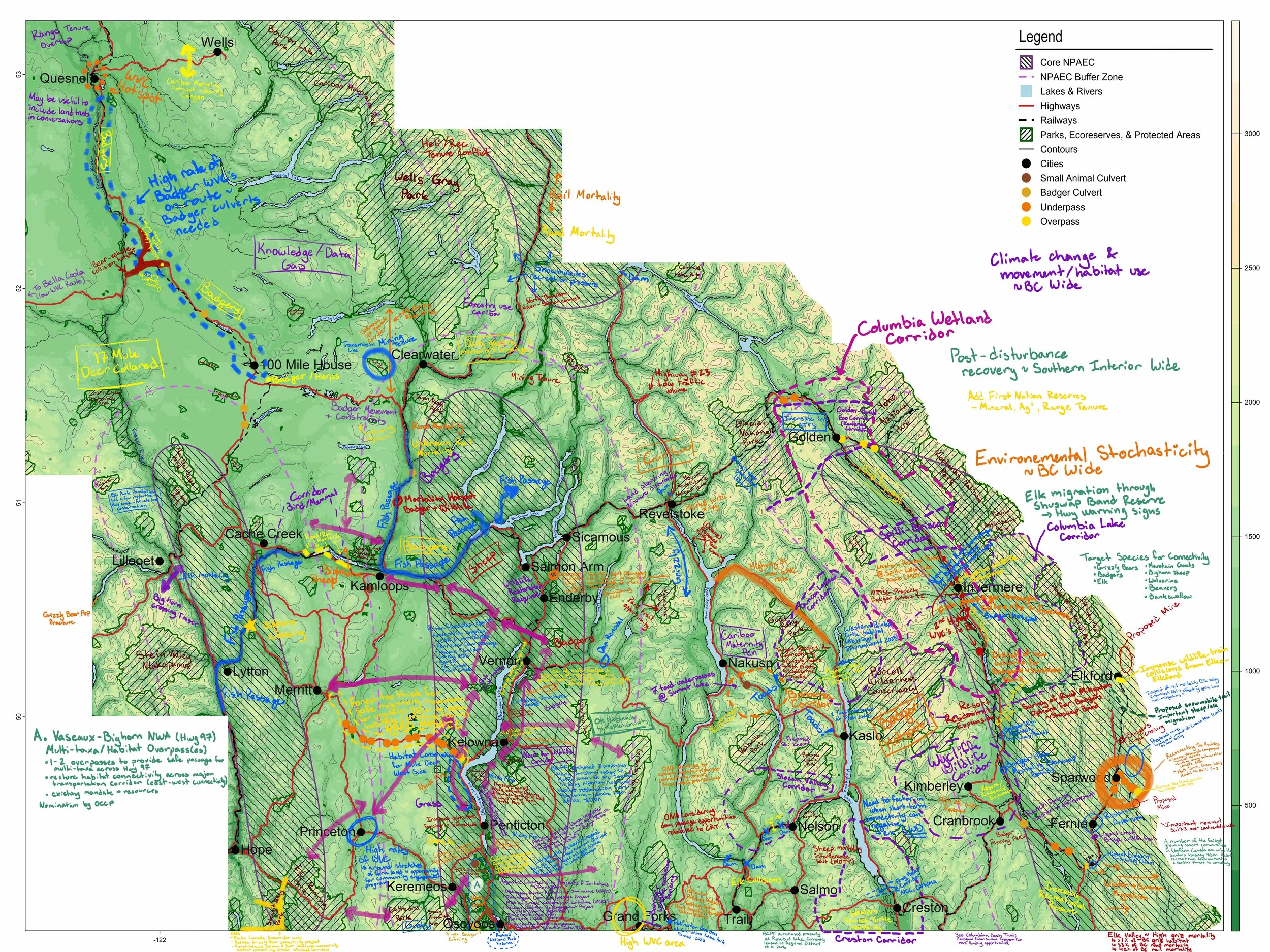
Detail of annotated map. Maps and GIS by Robin Blott.
Day two of the Corridors and Crossings Forum, Kelowna, June 2025. We'd just unrolled a set of large printed maps of BC's Southern Interior across the tables and put a handful of markers down beside them (background discussion paper that informed the forum can be found here). There was some unease, and then someone leaned in and started annotating, and within ten minutes every map had three or four people standing over it.
The setup was simple. The maps were based on the "caterpillar" corridors from Canada's National Priority Areas of Ecological Corridors (Canadian Geographic has a great interactive map). People could mark anything relevant. Wildlife corridors they were working on. Roadkill hotspots they knew about. Data gaps they were frustrated by. Areas of ecological concern. Markers were available. The map was open.
The maps left the room covered. Elk migration routes. Wetland corridors. Post-disturbance recovery zones. Notes about climate-driven habitat shifts. First Nations, NGOs, government agencies, and universities had layered decades of regional knowledge onto a few sheets of paper in an afternoon.
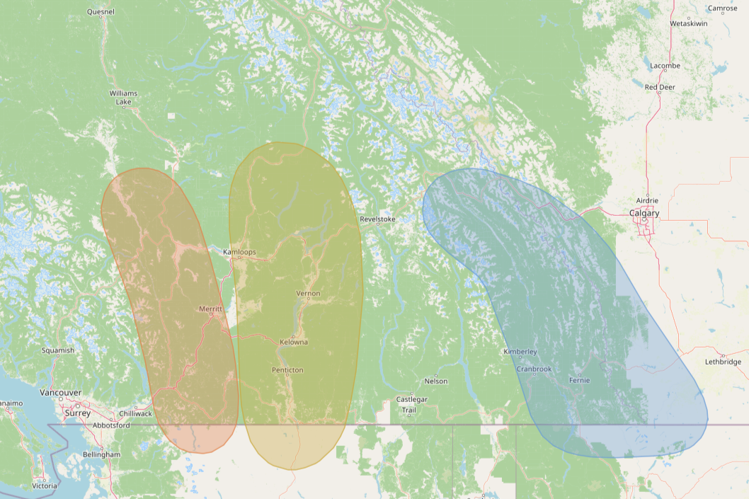
The three ecological corridors that were the focus of the workshop. From west to east: North Cascades to Fraser Plateau, South Okanagan to Thompson-Shuswap, Southern Rocky Mountain Trench.
The design choice that made it work
I framed the exercise as relationship-building, not data collection. Someone in the room push back on the framing, and that inspired an unplanned discussion on data sensitivity, Indigenous knowledge sovereignty and data sharing agreements. This discussion, initiated by someone steeped in traditional ecologic knowledge and the ethics of data sharing, built the foundation of trust by clairifying what I was expecting, and the purpose of the mapping exercise.
Some people in that room had formal authority over the land. Others were asserting rights to it. Others were trying to influence decisions from the outside. A data-extraction exercise would have collected information and undermined the actual purpose of the workshop, which was to build trust and open channels between people who don't usually share a table. The relationship-building frame produced something else. A shared place where people could contribute what they were comfortable with, on their own terms.
What it revealed about the room
No single organisation in that room held a complete picture, and everyone knew it. In fact, the Southern Interior is a puzzle, and everyone in that room had a piece. The pieces have to be shared piece by piece, in trust and in collaboration, so that the corridors that cross from one jurisdiction to another stay intact.
The knowledge we needed was already there. It just needed a process, and a place to go, so all of the pieces could find each other.
Watching what people chose to put on the map, and what they held back, was the most useful part of the day for me. The contributions told one story. The silences told another. Trust was present, but partial. People were willing to talk about their work in broad terms, less willing to commit specifics to paper.
That's not a failure. That's an honest starting point. The next pieces of the puzzle come later, and they come from the same place: the relationships we built in that room.
The craft question underneath it
Mapping exercises become extractive easily, and quietly. My job was to design the thing so that contributing felt like building, not surrendering. In this case that meant being explicit about what the exercise was not. Not a data grab. Not a planning document. Not binding on anyone afterwards. Once that was clear, people could engage with what it actually was: a chance to make their knowledge visible, to see others' knowledge alongside it, and to start to understand the scale of what a regional collaboration could hold.
The annotated map that left that room wasn't a dataset. It was a first draft of a shared understanding. That's what a good opening exercise produces. Not the answer. The first version of the question the group is going to spend the years ahead answering together.
Background: the discussion paper that informed the forum is [here]. Canadian Geographic has a useful interactive map of the National Priority Areas of Ecological Corridors [here]. Maps and GIS by Robin Blott.